In more than 25 years of practice, I have worked on projects that reached four billion dollars in cost. In all that time, urbanism never came up in a meeting with a developer or an authority. No brief asked for it. No approval depended on it. Yet I have also written 17 articles on urbanism, based on nearly 170 research papers. And I found the same ideas inside the work we did every day.
This article explains that gap. The role of urbanism in professional practice is real, but it is hidden. Urbanism is a field of study. It does not hand practitioners a rulebook. What it gives them is research findings. Over time, those findings turn into concepts, standards and rules. By then, nobody calls them urbanism.
I follow scale. I start with the city, move through landscape, urban form, density and urban design, and end with the building. A last section looks at governance, the layer that decides which research reaches a project and which does not. Each section ends with what I saw in practice and what the research led to.
From problem to rule: why urbanism began
Urbanism did not begin as a design philosophy. It began as a response to a health emergency. Nineteenth-century industrial cities grew faster than anyone could plan them. Workers lived in crowded, badly ventilated housing with poor sanitation. Diseases such as cholera and tuberculosis spread through the streets.
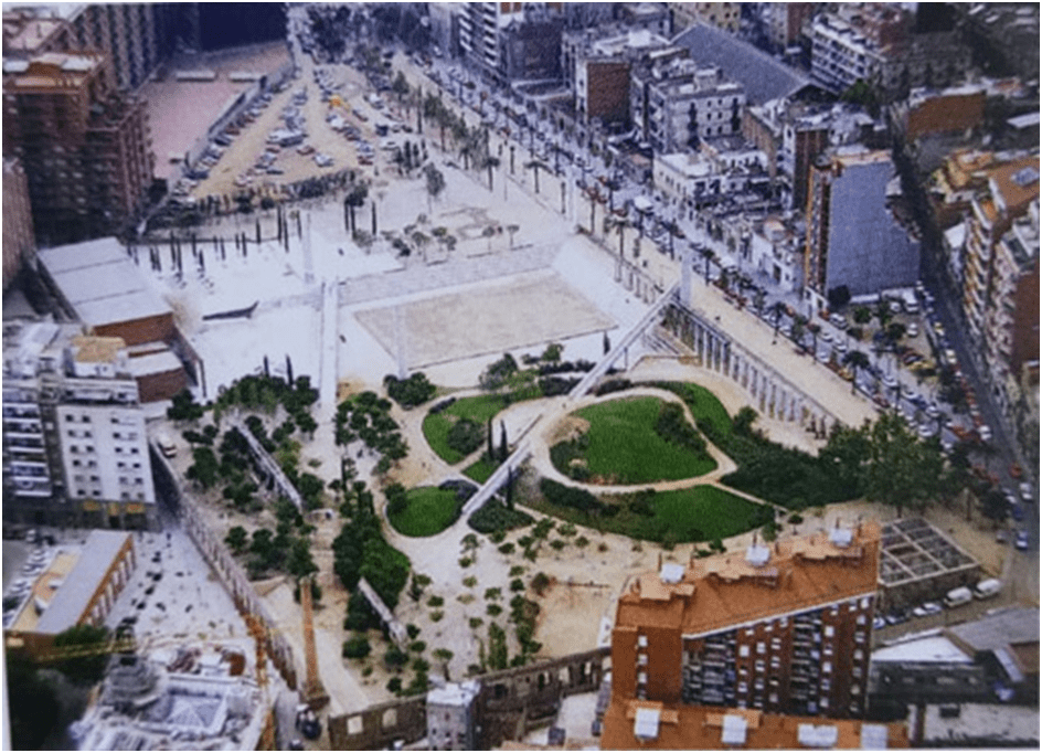
The first answers came from observation. In Britain, Chadwick linked living conditions to disease. Booth and later Geddes recorded how people actually lived, and Geddes argued for a survey before any plan. In Spain, Ildefons Cerdà studied Barcelona, designed its Eixample extension, and published his general theory of urbanization in 1867. He treated the city as something that could be studied and then designed for light, air, movement and health.
These studies produced concepts: minimum space, light and ventilation, limits on density, adequate street widths, and the separation of uses that harm each other. The concepts then became rules. Britain passed public health and housing laws. In the United States, tenement reform led to the 1916 New York zoning resolution. Model zoning laws followed in the 1920s, and the courts upheld zoning in the Euclid decision of 1926.
Early building ordinances show the same step clearly. In 1880, Baumeister set a normative ordinance that limited buildings to four storeys and kept height no greater than street width (Berghauser Pont and Haupt, 2009). That is research turned into a rule.
These were separate national paths answering the same problem. They share one sequence: a problem, then research, then a concept, then a rule. Today, an architect who checks a plot ratio, a height limit or a land-use class is applying the result of that research. Most never hear the word urbanism while doing it.
What urbanism is, and what it is not
This article draws on a series of 17 that looks at urbanism from the point of view of the profession and its practice. The series asks which topics matter in practice and where they enter the design process. It asks who the major players are, and who can change the quality and character of a project and its location. It also asks where, in architecture and urban design, a defect or an act of neglect leads to a minor or major failure. The first article, The dialectic of architecture and urban design, sets out these questions.
Ask four authors what urbanism is, and you get four answers. Chase, Crawford and Kaliski (2009) describe everyday urbanism as the spontaneous, repeated actions that happen between home, work and institution. Ellin (2012) calls good urbanism a few added tools that build on the existing strengths of a place. Hou (2015) presents urbanism as critical inquiry that joins theory and action. Sordi (2016) shows that landscape urbanism rose in the late 1990s as a critique of urban design, which could not deal with the scale of urbanization.
These are a description of use, a design attitude, a critical stance and a critique of a profession. None states a cause-and-effect claim that can be tested. This explains the frustration many architects and urban designers feel. The word promises a method, but the sources offer a way of looking.
The most useful distinction comes from the study of urban form. Oliveira (2022) separates cognitive studies, which explain how cities form and change, from normative studies, which say how cities should be planned or built. I use the same split. Urbanism has a research layer, which is old and became the rules above. It also has a label layer, the newer “-urbanisms”, which are mostly discussion. Planning and urban design are the applied branches. Urbanism supplies the knowledge, and they apply it.
City scale: economy, ecology and the digital city
At the largest scale, the research describes what a city is. Tonkiss (2015) treats city-making as a social process that links how people use space to how the environment is built. Ortiz (2014) points out that designers trained at 1:50 or 1:500 struggle at 1:5000 and more. Florida and colleagues (2009) show that economic output is concentrated in a few metropolitan areas. Newman and Jennings (2008) describe the ecological footprint, the load a city places on nature. Van der Ryn and Cowan (2007) argue that design should work with living processes.
These findings reach practice unevenly. The economic view arrives in full. It is the developer’s market study, the cost plan and the infrastructure demand in the brief. The ecological view arrives in part, through environmental assessment, and mostly when a regulator or a developer asks for it. The social view has no formal route at all.
The digital city shows the same pattern. Weltevreden and Atzema (2006) studied how Dutch city-centre retailers combined shops and online sales. Sadowski (2020) describes how platforms change who operates urban services. Practice absorbed this quietly. Retail areas in a market study are now sized with e-commerce in mind. Nobody writes “urbanism” in that study.
From practice. Disease spread is one of the weakest points of a city. Designers need to understand how disease moves through the city and what can stop it. They also need to know how to slow it until a lasting solution is found. This is where architects and urban designers meet. Together they design efficient, healthy sanitary systems. They also design indoor and outdoor spaces that keep the air clean and healthy at all times. I discuss this in Challenges of city design or planning.
In urban design, people who use cyberspace in an area still need physical access to the businesses they use daily, such as taxi offices and small bank branches. Short trips cut travel costs. Public transport should be easy to reach, to ease the financial load on low-income residents. Green space should connect to neighbouring areas to keep social networks alive and strengthen community ties. Housing, whether public or mixed, should meet a high standard of comfort. Construction costs and rents should match the incomes of the people living there.
Cyberspace has also changed how people think and spend. It helps low-income people manage their money, but it has hurt many small retailers. Retailers and manufacturers now reach consumers differently and plan their stores differently. Some businesses have no physical location at all. A few months ago I booked a rental car in Dubai and, after chasing the company, found that it operated from the United Kingdom. It had no office. Its cars sat in a large local agency under an agreement, and were handed to registered customers on a contract sent from the UK. A service can now run in a city with no office in it, which is the point Sadowski raises about who operates urban services. More in Cyberspace, cityscape and local economic development.
What this led to in practice. City-scale research gave me concepts and not rules: the city as an economic engine, the ecological footprint and the digital city. They reach my projects as the market study, the infrastructure demand assessment and environmental assessment, which are recommendations that a developer or regulator chooses to apply.
Ecosystem and landscape: concepts without a single meaning
Ecological urbanism and landscape urbanism are the clearest examples of concepts that practice borrows without adopting. Lorrimar-Shanks and Owen (2015) say that ecological urbanism has no definitive meaning and may not want one. Lin (2018) traces its roots to the countercultural movements of the 1960s and 1970s, and notes that Japan began eco-city projects in 1997.
Landscape urbanism has five definitions in my own survey. Weller (2008) describes it as a bridge between landscape design, ecology and planning. Donadieu (2006) links it to the redevelopment of industrial land. Waldheim (2006) describes it as a multiscale approach that uses processes rather than forms as the basis of design. Together they describe a lens and not a method.
The ideas still reach practice. They arrive as site analysis, which Morris (1994) divides into natural determinants such as topography, climate and materials, and man-made ones such as economics and politics. They arrive as drainage strategy, green corridors, microclimate design and brownfield remediation. Sustainability is not mandatory on most projects. Architects apply parts of it because it is good practice, and some developers demand it. The label “ecological urbanism” does not appear in the brief.
From practice. In my view, landscape urbanism is about the natural landscape. When urban designers, landscape architects and architects take the natural landscape into account, it helps shape the urban form. The aim is to protect the urban fabric and the physical environment, and to anticipate future scenarios in design, environment, planning and development. These scenarios also cover human prosperity and the protection of living species and ecosystems. I develop this in Urban change and landscape architecture transformation.
A city plan should have as little impact as possible on the local ecosystem. The site should need only minimal infrastructure, such as roads, transit and underground services. The development should connect well with nearby projects, so that residents need to travel less. Corridors should link the site to its surroundings and keep movement safe and continuous. The plan should add ecosystem elements such as lawns, trees and water features, and it should promote sustainable strategies for energy, water quality, air quality, light and heat. See Ecological urbanism and ecosystem dialectic.
What this led to in practice. These topics gave me concepts and recommendations but no rules of their own: respect the natural systems of a site, use landscape as structure, and regenerate brownfield land. They reach my projects as site analysis, drainage and green-corridor strategies, and as environmental or rating requirements where a regulator or developer asks for them.
Urban form and fabric: measuring the city
Research on urban form produced tools that firms now use without a second thought. Li and colleagues (2016) review ways to assess urban fabric, including space syntax, isovist analysis and density indicators. Berghauser Pont and Haupt (2009) show that density is more than one number. They describe it through three measures: floor space intensity, ground coverage and network density. Their work, called Spacematrix, links density to light, air movement, building height and open space.
These ideas live on in everyday decisions: movement analysis, plot ratio, setbacks and street sections. Heritage works the same way. Swensen (2012) shows how fragmented planning makes it hard to fit historic fabric into new development. In practice, authorities protect historic areas by regulation. The research reaches the project as a constraint.
On my own projects, the firm decides how the town fits its plot and surroundings. We connect road networks without creating congestion, link pedestrian paths to raise everyday use, and connect transit nodes. These choices come from this body of research. We make them as ordinary competence, not as urbanism.
Table 1, The interaction of architecture, urban design, with the urban fabric, urban form, and sustainability in practice.
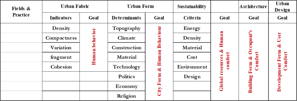
As the table 1 shows, architecture in practice aims at a good building form and an efficient function, and together these contribute to the creation of the city. Urban design works on a larger scale. It aims at a good development form and at user comfort. I believe both professions should look for human comfort in their studies of urban fabric and urban form. The practical questions are which fabric pattern works best, and which urban form gives the best quality of urban living. I show one district where the sequence ran the other way in the governance section below. The full article is Urban fabric or urban form sustainability.
What this led to in practice. Research on form gave me measurement methods and a few rules. Space syntax and density indicators remain analysis tools, while plot ratio, setbacks, street sections and heritage protection became rules that I apply through codes and conservation controls.
Density, intensification and smart growth
Density is where research most clearly became a rule. Compactness, in contrast, is still disputed. Van Grunsven (2003), reviewing studies of compact cities in developing countries, notes disagreement over the right spatial model and over the forces that drive compaction. The idea that higher density can cut travel, energy use and pollution is widely used. Its detailed form changes with land price and market.
Smart growth is a case of research written into policy on purpose. Chen (2000) lists the costs of sprawl: congestion, rising taxes, disinvestment in older areas, lost open space and pollution. The ten smart growth principles appeared in 1996 (Liu, 2012). Kushner (2002) then asked who benefits. He warned that smart growth and New Urbanism can deepen ethnic separation and reduce opportunity for the poor and for new immigrants. That is research auditing policy.
Intensification follows the same path. Dovey, Pike and Woodcock (2016) found that small plots, parking requirements and high rents block the intensification that policy wants along transit corridors. A national policy statement on urban development in 2020 directs authorities to intensify near centres, jobs and public transport. Research explained the aim, policy set it, and cost and plot size decide the result.
Transit-oriented development is the best example of hidden use. Almost every large firm plans around transit nodes today, and none of us stops to cite a source.
From practice. Diversity in architecture is applied in different ways. On one mega project in the Middle East, I reviewed a villa development and advised the design team to offer villas in several sizes, with two, three and four bedrooms. Buyers and renters on different incomes were attracted to the range, and the developer sold 30% of the villas at the target price before the schematic design phase ended.
The same development included 12 residential buildings. The consultant had been changed three times, because the team did not know the local regulations and the market research, which came mainly from the UK, was weak. I reviewed the design and proposed a mix of studios and one-, two- and three-bedroom flats, with at least some one-bedroom units, because these sell and rent most easily in that location. One of the largest local consultancies then led the design and construction supervision through to handover. Here diversity reached the project as a unit mix driven by market demand, not as the social diversity that Kushner writes about. See Diversity, smart growth and future urban design.
In an intensification scheme, I see the architect’s role as analysing the discounted project cost and studying densities within a plot, to find which density suits each land use, commercial or residential. The architect also helps convince landowners to accept intensification by giving them a feasibility study of construction cost and revenue. Urban designers define, in the urban development plan for the programme, the locations to be intensified and the densities that match population growth and business demand. That demand includes the types of workforce the area needs, which in turn sets the land uses. They show how jobs will be supported, through services, amenities, urban space and landscape. They also advise the private and other parties on how to find funding. Finally, they plan how the programme can avoid its main barriers, especially land ownership, and respond to international environmental policy. Landowner consent and finance are barriers that Dovey and colleagues do not cover. More in Intensification policy and urban development barriers.
In high-density development, I believe architects should focus on a variety of unit types. Each unit should have generous usable space, views, and private outdoor space such as a balcony. Building type, colour and materials deserve attention. Architects should also consider current technology for mechanical, electrical and plumbing systems and for lifts. Building orientation should reduce heat gain and let air move through the units. Recreation areas inside the building or on the plot raise residents’ quality of life.
When urban designers receive a development proposal, they should check the relationship between density and the amount of urban space and landscape, and ask for commercial frontage. This creates jobs and gives access to daily services such as restaurants, laundries, supermarkets and cafés. They should check the connections within the high-density development: green space, cycle routes and pedestrian paths. The plan should allow for future growth in movement through public transit nodes, and for visitors to the area. It should also place offices where they reduce reliance on cars. This is the same idea Berghauser Pont and Haupt describe, applied as a review step. See Density, compactness and transit-oriented development.
What this led to in practice. Research here gave me the strongest rules and policies in the series: density limits, compact growth, smart growth principles and national intensification policy. I apply them as plot ratios and transit-oriented planning, while cost, plot size and landowner consent decide how far they are carried out.
Urban design, regeneration and public space
Regeneration research gave practice a distinction that now structures whole programmes. Leary and McCarthy (2014) separate renewal, which is mainly physical, from regeneration, which is a holistic response. Maria and Tabasso (2016) show that nineteenth-century European renewal used demolition and rebuilding to bring sanitation, light and air. That is the origin story again. Modern regeneration targets deprivation, and indices of deprivation measure health, education, housing, crime and living environment to decide where money goes. Here measured research directly steers public funding.
Townscape shows that the same idea can end very differently in two places. In Japan, rapid growth after 1960 destroyed historic towns, local committees pushed back, and the state defined preservation areas (Hohn, 1997). Townscape became a legal system. In the United Kingdom, Cullen (1978) recorded the elements of towns with fine sketches. I surveyed town and city sectors in Lancashire, Manchester, Liverpool, Bath, Bolton and London and found no distinctive change from the post-war period. The literature praises the movement, but I could not find where it changed what was built.
Public space follows a plain chain in practice. The planner allocates public space and nodes in the local plan. The urban designer studies each space in detail. The architect then builds around it.
From practice. Urban designers can link public art to wider themes such as the environment, education, industry and society. In Japan, Kita-Urawa Park holds many works of public art in different locations. One of them, the Bankara statue, reminds visitors that a high school once stood on the site. It shows a schoolboy in uniform with a cap on his head. The full article is Urban design, public art and space quality.
When a development or preservation programme starts, architects follow a set of steps. They define the historical value of the buildings in the town. They identify the cultural values that matter to its society. They then examine how development might change the way of life there. Architects work through all of this without losing sight of innovation, function and appearance. Urban designers work with them to decide where the new architecture should go, and how it should be shaped and oriented. They study the effect on the historic setting, the need for new urban or green space, and the effect on human and vehicle movement in the town. They assess how development will improve the local economy, meet future demand as the population grows, and provide employment. They also take into account the city’s development policy and higher-level political policy. I treat townscape as a process, not a one-off change. See Townscape is about urban change or process.
What this led to in practice. Regeneration and townscape research gave me recommendations and a few instruments: the renewal and regeneration distinction, deprivation indices that target funding, and preservation districts in Japan. They reach my work as funding targets, regeneration programmes and public space plans, while in the UK towns I surveyed I found little visible change from townscape thinking.
Architecture: working inside the results
The architect receives all of the above as limits. Plot ratio, height, setbacks, frontage, heritage rules and open-space requirements all arrive in the brief, already shaped by research that no one names. This is why many architects feel urbanism is missing from practice. In fact, they work inside its results every day.
What the architect and urban designer can still do is ask where a rule came from. A rule with a known origin can be applied with judgment. A rule with no known origin tends to be applied as a formula.
From practice. Many countries in Europe moved away from physical planning. They came to see it as a cause of segregation, a limit on freedom and an undemocratic practice. A team of specialists is right for urban planning, but I believe architecture should be a major part of that team, not a minor one. Did the problems go away? Or do they still happen, despite years of international attention, policies and treaties? In recent decades, planning in many developed countries has moved from fixed policies to free-form ones. The same problems keep returning. I ask what the main cause is, and why they keep damaging the physical environment and producing low-quality architecture. I take up this question in Urban regeneration and the architecture crisis. My answer is in the next section: the same conditions that put the developer’s programme first also keep research and architecture out of decisions.
What this led to in practice. Architecture receives the results of this research as limits and not as methods: plot ratio, height, setbacks, frontage and heritage rules. My contribution is to ask where a rule came from and to apply it with judgment.
Governance: the layer that decides
If research is this useful, why is it absent from the meeting? The governance literature gives an answer. Harvey (1989) describes entrepreneurial governance, where the public sector and private partners work together and the private sector leads. Peck (2014) and Sýkora (2009) show how market-led approaches fail. Davidson and Frickel (2004) find that environmental governance is a contest between competing interests, with agencies that have few resources and states constrained by capital.
International bodies keep repeating the same principles. Lange (2010) and the UN Habitat III papers (2016) list inclusion, rights, sustainability and support for informal livelihoods. The lists change little, and the projects change less. When I coded the governance literature, four concerns kept appearing: human rights, economic interest, national loyalties and religious commitments. In each, the main question comes down to how capital is directed and managed.
In my practice, that is exactly what I see. The developer sets the programme from a market study and a cost plan. The firm decides how the project fits the plot and its surroundings and limits the damage to both. Urbanism is not in the room because the system puts other inputs there.
Research still audits this system. Galster and Peacock (1986) and later Rérat and colleagues (2010) document how regeneration can replace lower-income residents with richer ones. He (2010) links the process in Shanghai to capital markets and neoliberal urban policy. This is the critical function of urbanism, and it is rarely invited into briefs.
From practice. Urban designers care about how planners and related disciplines build local plans. Those disciplines include geographers, economists, engineers, transport planners and historians. I ask what in the political process shapes the local plan, and what should change. I look at the parts of the city that are easy to miss: the decline of urban space, the loss of green space and nature, the erosion of local character and cultural context, the effect of building form on the fabric and its daily use, the performance of the transport network, and the spread of economic activity that keeps a city alive and prevents decline. Silicon Valley is often cited as an innovation district that grew in a supportive political and policy setting. It produced technologies that still affect daily life. A district in the Middle East was later planned on the same idea. In my view it did not deliver comparable results, because it lacked the conditions that made the original work, including a clear urban policy and a strong research base. Political governance can create urban change that fits a city’s growth and responds to what society needs. See How does political governance create urban change?.
Urban designers help manage and coordinate development in the city, and part of that work is identifying development opportunities. Economic conditions point to them. In a construction boom, some functions grow fastest. Open policies on foreign investment and lower overheads, such as tax, can favour housing, residential and industrial projects. Public economic policy can lead to landscape projects, transit nodes and stations, road networks, rail links to neighbouring countries, ports, border facilities and plants. A rise in tourism signals demand for hospitality projects. What a city consumes is another guide. A city that imports most of its eggs and milk may need agricultural projects. A city that brings in concrete from elsewhere may need a local concrete plant. Damage to the environment, such as polluted areas or lost marshes, lakes and rivers, can lead to environmental projects. The list continues. See Economic governance relation to urban development.
Urban designers need to consider who a new development will serve. Its location should give access to affordable transport and to jobs. Services should offer the same quality of life to low-income residents as to middle- and high-income ones, including good schools and hospitals. Housing should come in a range of sizes, so that low-income households can buy or rent. Commercial and mixed-use areas should give these residents access to work. A development strategy should give careful attention to land use and allow a wide range of industries. Some buildings create many jobs. A hospital needs doctors in several specialties, nurses, radiographers, laboratory staff, pharmacists, maintenance workers, cleaners and security staff. It also supports suppliers of medical products and materials, affordable public and private transport such as taxis, and food providers such as restaurants and cafés. These measures reduce the risk that regeneration replaces existing residents. See Gentrification towards modern political governance.
One business district in a Middle Eastern city is widely promoted as a model of urban development. It covers 4.67 square kilometres and was planned in 2005 by an international firm. It took nearly 18 years to build and is still not complete. I worked on the design development of four of its towers, on the client side. The area is divided into adjacent plots, and the towers ignore their surroundings. They have fully glazed external envelopes and depend on air conditioning all day.
Most tenants rely on basement car parks. This moves parking off the street, but the traffic on the roads stays the same. There are no proper pedestrian corridors, so people walk along the main roads in extreme heat. The transit station serves only the towers next to it. Most of the district can be reached only by car, by a walk of more than 25 minutes, or by a bus that runs to a strict timetable.
The development was built first, and the main arteries followed. The metro came later, and the bridges, main roads and sub-roads were built after about 75% of the development was complete. Green space is no more than about 1% of the area, mostly road islands between two lanes. A decorative water feature does not make a district environmentally sustainable when it serves nothing around it. Taking part in world summits means little when results on the ground are small. This district shows how development can ignore global environmental governance, sustainable development and community building in planning and urban design. See Does environment governance impact city urban form?.
Good urban governance depends on three things. The first is capital set aside to fund the work. The second is a political system that adapts to change and works well with other political systems during urban change. The third is enough knowledge and enough professionals to run the operations through to a successful end. This is the condition I found missing in the district above and in the housing project where the consultant was changed three times. See What are the key elements of good urban governance?.
What this led to in practice. Governance research gave me a critique more than a set of rules: entrepreneurial governance, displacement and the recycling of the same principles of good governance. In practice it explains why the developer’s programme leads, and it works as an audit of policy that briefs rarely invite.
Summary: where urbanism hides in practice
| Scale | What the research led to | Where I see it |
| City | Concepts | Market study, environmental assessment |
| Ecosystem and landscape | Concepts, recommendations | Site analysis, drainage, rating systems |
| Urban form | Methods, rules | Plot ratio, setbacks, conservation rules |
| Density and growth | Rules, policy | Density limits, transit-oriented planning |
| Urban design | Recommendations, instruments | Funding targets, preservation districts |
| Governance | Critique | The brief, public-private partnership |
What this means for firms and authorities
The lesson is not that practitioners should start citing urbanism. It is that they should know what it has already given them. I suggest three habits.
First, trace each rule to its origin. A plot ratio or a street width has a history, and knowing it helps a firm argue for a better variation. Second, ask the audit question. Research shows that policies often deliver something different from what they promise, so a project should check who gains and who is displaced. Third, put evidence into the brief. A movement analysis or a post-occupancy review costs little, and it brings research to the table before decisions are fixed.
Conclusion
The urbanism role in professional practice is that of a research and critique layer. Its findings travel from studies to concepts, from concepts to standards, and from standards to briefs and approvals. Along the way the label drops away. That is why 25 years of practice on large projects can pass without anyone saying the word, while the work is full of its results.
The value of urbanism does not depend on how often practitioners cite it. It depends on how well it exposes the gap between what policy and design promise and what happens to people and places. A field that does that deserves a seat in the room.
References
Berghauser Pont, M. and Haupt, P. (2009) Space, density and urban form. Thesis.
Chase, J., Crawford, M. and Kaliski, J. (2009) Everyday urbanism. New York: Monacelli.
Chen, D.T. (2000) ‘The science of smart growth’, Scientific American, 283(6), pp. 84–91.
Cullen, G. (1978) The concise townscape. London: Architectural Press.
Davidson, D.J. and Frickel, S. (2004) ‘Understanding environmental governance’, Organization & Environment, 17(4), pp. 471–492.
Donadieu, P. (2006) ‘Landscape urbanism in Europe: from brownfields to sustainable urban development’, Journal of Landscape Architecture, 1(2), pp. 36–45.
Dovey, K., Pike, L. and Woodcock, I. (2016) ‘Incremental urban intensification: transit-oriented re-development of small-lot corridors’, Urban Policy and Research, 35(3), pp. 261–274.
Ellin, N. (2012) ‘What is good urbanism?’, Journal of Architecture and Urbanism, 36(4), pp. 247–251.
Florida, R., Mellander, C. and Gulden, T. (2009) Global metropolis: the role of cities and metropolitan areas in the global economy. Martin Prosperity Research.
Galster, G. and Peacock, S. (1986) ‘Urban gentrification: evaluating alternative indicators’, Social Indicators Research, 18(3), pp. 321–337.
Harvey, D. (1989) ‘From managerialism to entrepreneurialism: the transformation in urban governance in late capitalism’, Geografiska Annaler B, 71(1), pp. 3–17.
He, S. (2010) ‘New-build gentrification in central Shanghai: demographic changes and socioeconomic implications’, Population, Space and Place, 16(5), pp. 345–361.
Hohn, U. (1997) ‘Townscape preservation in Japanese urban planning’, Town Planning Review, 68(2), p. 213.
Hou, J. (2015) Now urbanism: the future city is here. London: Routledge.
Kushner, J.A. (2002) ‘Smart growth, New Urbanism and diversity’, UCLA Journal of Environmental Law and Policy, 21(1).
Lange, F. (2010) ‘Urban governance and the entrepreneurial city’. World Vision Institute.
Leary, M.E. and McCarthy, J. (2014) The Routledge companion to urban regeneration. Abingdon: Routledge.
Li, X. et al. (2016) ‘Assessment of urban fabric for smart cities’, IEEE Access, 4, pp. 373–382.
Lin, Z. (2018) ‘Ecological urbanism in East Asia: a comparative assessment of two eco-cities in Japan and China’, Landscape and Urban Planning, 179, pp. 90–102.
Liu, L.L. (2012) ‘An analysis of the influencing factors in new urban planning under the conception of smart growth’, Applied Mechanics and Materials, 174–177, pp. 2433–2439.
Lorrimar-Shanks, J. and Owen, C. (2015) ‘A critical approach to ecological urbanism in Hong Kong’, International Journal of Urban Sustainable Development, 8(2), pp. 110–125.
Maria, G. and Tabasso, M. (2016) From urban renewal to urban regeneration: classification criteria for urban interventions. Turin 1995–2015.
Morris, A.E.J. (1994) History of urban form: before the industrial revolutions. Harlow: Longman.
Newman, P. and Jennings, I. (2008) Cities as sustainable ecosystems: principles and practices. Washington, DC: Island Press.
Oliveira, V. (2022) Urban morphology: an introduction to the study of the physical form of cities. Cham: Springer.
Ortiz, P.B. (2014) The art of shaping the metropolis. New York: McGraw-Hill Education.
Peck, J. (2014) ‘Entrepreneurial urbanism: between uncommon sense and dull compulsion’, Geografiska Annaler B, 96(4), pp. 396–401.
Rérat, P., Söderström, O., Piguet, E. and Besson, R. (2010) ‘From urban wastelands to new-build gentrification: the case of Swiss cities’, Population, Space and Place, 16(5), pp. 429–442.
Sadowski, J. (2020) ‘Cyberspace and cityscapes: on the emergence of platform urbanism’, Urban Geography, 41(3), pp. 448–452.
Sordi, J. (2016) Beyond urbanism. Trento: Listlab.
Swensen, G. (2012) ‘Integration of historic fabric in new urban development: a Norwegian case study’, Landscape and Urban Planning, 107(4), pp. 380–388.
Sýkora, L. (2009) ‘Post-socialist cities’, in International Encyclopedia of Human Geography. Elsevier, pp. 387–395.
Tonkiss, F. (2015) Cities by design: the social life of urban form. Cambridge: Polity Press.
UN Habitat (2016) Urban economic development strategies. Habitat III papers.
Van Grunsven, L. (2003) Review of Compact cities: sustainable urban forms for developing countries, Journal of Housing and the Built Environment.
Van der Ryn, S. and Cowan, S. (2007) Ecological design. Washington, DC: Island Press.
Waldheim, C. (ed.) (2006) The landscape urbanism reader. New York: Princeton Architectural Press.
Weller, R. (2008) ‘Landscape (sub)urbanism in theory and practice’, Landscape Journal, 27(2), pp. 247–267.
Weltevreden, J.W.J. and Atzema, O.A.L.C. (2006) ‘Cyberspace meets high street: adoption of click-and-mortar strategies by retail outlets in city centers’, Urban Geography, 27(7), pp. 628–650.
[…] Urbanism Role in Professional Practice: How Research Became Hidden Rules […]
[…] Urbanism Role in Professional Practice: How Research Became Hidden Rules […]
[…] Urbanism Role in Professional Practice: How Research Became Hidden Rules […]
[…] Urbanism Role in Professional Practice: How Research Became Hidden Rules […]
[…] Urbanism Role in Professional Practice: How Research Became Hidden Rules […]
[…] Urbanism Role in Professional Practice: How Research Became Hidden Rules […]
[…] Urbanism Role in Professional Practice: How Research Became Hidden Rules […]
[…] Urbanism Role in Professional Practice: How Research Became Hidden Rules […]
[…] Urbanism Role in Professional Practice: How Research Became Hidden Rules […]
[…] Urbanism Role in Professional Practice: How Research Became Hidden Rules […]
[…] Urbanism Role in Professional Practice: How Research Became Hidden Rules […]
[…] Urbanism Role in Professional Practice: How Research Became Hidden Rules […]
[…] Urbanism Role in Professional Practice: How Research Became Hidden Rules […]
[…] Urbanism Role in Professional Practice: How Research Became Hidden Rules […]
[…] Urbanism Role in Professional Practice: How Research Became Hidden Rules […]
[…] Urbanism Role in Professional Practice: How Research Became Hidden Rules […]