Urbanism: Density, Compactness & Transit Oriented Development is the twelfth article of a series1,2,3,4,5,6,7,8,9,10,11,12,13,14,15,16,17 . It assesses the dialectic of architecture and urban design in the urbanism field. I will go through this relationship from the top scale of urbanism in the city to the smallest scale of urbanism components of urban space.
Table of content
What are the 5 forces shaping density and compactness creation.
Evolution of research and practice (density → compactness).
Evolution of planning practice (TOD as a response).
Limits of planning models (capacity, infrastructure, real-world constraints).
Role of architects and urban designers (translating theory into practice).
Urbanism is correlated to Urban density, compactness, and transit-oriented development in various dimensions such as policy, economics, environment, social, and development physical form. Specifically, I will show the forces shaping urban density and compactness
What are the 5 forces shaping urban density and compactness
In politics, governments issue political policies and governance to direct and control the amount and the location of urban development. In the world, countries that depend on fixed and Semi-fixed masterplan governments determine the amount of development on specific land use and plots. And that relates to many factors which I will illustrate later in this article. In the Western world, countries have more flexible policies, depending on the political approach of the country. That for the amount of development and its relation to land uses. In general, governments in the world are concerned about the amount of development because of many reasons. Its direct correlation to market stock, development units, prices, and its relation to businesses operating in the area. Stock unit prices affect the prices of all its components, especially the building materials and related industries.
For the private sector, the owner of the land or the developer decides the amount of development on the land. Surely, depending on many factors like lease time length and its yearly payment. Planning authorities play a vital role in the realization of the development proposal. Also, the allowance of the allowable densities on the land and its uses
Development has to be aligned with economic determinants and efficiency measures. Densities are defined and determined when doing careful land uses assessment for the area of development and adjacent plots. The densities of development are related to many determining factors. Land uses are generated upon conducting land use modeling and the distribution of the land uses depends on the location and the distance to the CBD. Land use Value determines what type of land is used in a certain location in a development. And determines the plot development criteria. According to that densities are determined based on the land value whether it is bought or rented. And the revenue expected to be obtained after development.
The growing demand for development which defines the densities of the development is hindered by the available funds from the public or private sector. See Figure 1 example of high-density development in Hong Kong.
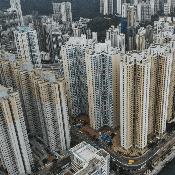
Densities of development if not studied, assessed, and planned well lead to several destructive environmental issues. This is the third of the forces shaping urban density and compactness. The increase in densities leads to an increase in the heat radiation to the environment. From the building material used in constructing the building especially concrete. The increase in the heat in the environment increases the heat island effect. Surely, when accompanied by the increase of hardscape in the development. An increase in density requires the buildings to be designed and aligned with sustainability requirements for Air, Light, and Sun. In many cases, development removes many parts of the ecosystem. Doing so causes the shift and damage of species and damage to environmental earth balance.
Densities of development have a direct correlation to social factors. The increase in density reduces the measures of high-quality and peaceful living. That leads to social segregation and turning the development into cantons of ethnic groups. Social segregation creates social problems such as crime, drugs, prostitution, and turn societies into cantons. Specialists must study and plan the densities of the development. To account for various levels of income and to create a mix and homogenous communities.
Evolution of research and practice (density → compactness)
Density has been an active topic in urban planning, design, and development since the creation of cities in the world. The increase in densities leads to the demand for travel and load on existing transit and the requirement for its development to take new loads. In research academics, and practice an enormous amount of research papers, publications, seminars, and professional studies on the compactness of development have been presented.
Van1 presents a variety of research papers concerning compact cities in developing countries from India, China, Africa, Chile, Brazil, and many others. In the research, he points out that there are disputes over the desirable spatial models for compact cities. There are many debates over how cities are going to be compacted. This is due to the unknown and unclear forces that determine the degree of compaction of existing settlements. So, what is a compact city? What does it serve?
Van indicates that Contemporary compact city approaches have become one form of achieving sustainable urban development. For him a contemporary compact city is “ to increase built area and residential population densities; to intensify urban economic, social and cultural activities and to manipulate urban size, form, and structure and settlement systems in pursuit of the environmental, social and global sustainability benefits derived from the concentration of urban functions”.
It is clear from his definition of the direct relationship between densities and compactness of urban development. But what does the compact city model serve?
He illustrates that the rationale for the compact city lies in the assumption that high densities can reduce travel demands energy consumption and pollution and provide more environmental and quality-of-life benefits. This model is not the identical model for development or city. Many cities in the world include compact model criterion. For example, high-density development such as New York, Hong Kong, Tokyo, and others. This model is the result of two main factors city population growth and commuters, and the high land price value. The compact model faced lots of opponents from the urban planning field and these supported the mixed-use model. The compact city model can serve the sustainable development requirements. Surely, when the compactness is based on mixing land uses not zoning.
Example of the misconception of the relation of density and compactness – urban development project from Dubai and Europe
Video 1 below shows one of the examples of a compact model in one of the Middle Eastern cities. Specifically, this area is part of the city waterfront, consisting of 4 square kilometers. Moreover, the area includes three types of land uses: residential, offices, and a mall. As presented in the video, the area features unlimited height development. However, regardless of the various problems that exist in this development, which range from traffic congestion during peak hours to a lack of diversity, high rent and lease prices, and insufficient parking lots serving the offices and outside areas, there are also issues of privacy due to the extreme proximity of the high-rise buildings, among many others.
For instance, in this area, if a resident from another area enters, they need 15 minutes just to reach the outer ring road to exit the development. Consequently, this example serves as one of the poor illustrations of compactness in the area.
Now one can pose a question why we don’t see such kind of compacted development for example in London, Barcelona, Stockholm and other cities in EU? European firms planned and designed this development. Also, they done most of the architecture of the buildings.
Yolanda2 presented a thesis on the urban density correlation to space and urban form. The thesis studies the density in three cities in European countries, the Netherlands, Germany, and Spain. The study provides very useful information on the urban densities in these European cities regardless of what Yolanda says about one of these cities. The research builds on creating three indicators for the study of densities and encourages researchers, academics, and practitioners to follow this model he named Spacematrix. He says that We suggest that density should be treated as a multivariable phenomenon, consisting of the three fundamental indicators intensity (FSI), compactness (GSI), and network density (N). This gives again the clear relation of density and compactness.
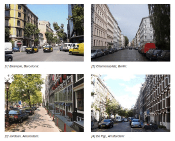
For him, the study of these three indicators is to analyze an urban fabric, and the effect of these indicators on light, air circulation, building heights, open space, green space, and other elements of urban development. One of the contradictions of this research is that it indicates that Baumeister presents a normative building ordinate in 1880 that defines a maximum four-story building density and building height not to exceed the street width. This is in extreme contrast to the density and building heights in the example above in the video regardless of the time length difference. Figure 3 shows the various examples of street width proportion to building height in three cities.
Evolution of planning practice (TOD as a response)
The research and debate over two decades regarding densities and compactness have led to various ideas and approaches in urban planning and design, which have had a significant impact on architecture. For instance, specialists invented the TOD (transit-oriented development) approach in response to the increased demand for the use of public transit, as well as population movement within the development, city, and commuters from other cities. Consequently, the government directed their policies of urban development, and the private sector encouraged locating their development proposals near transit in order to facilitate movement from the development to the city. Moreover, many developers around the world would suggest and choose to develop near transit nodes or even future development of transit nodes. Thus, the more the density increases, the more the development responds to the feasibility of the use of public transit.
In addition, movement from the development and from the city to it facilitates travel for work, shopping, leisure, education, and social purposes. As a result, public transit becomes more affordable for both the government and the user.
Limits of planning models (capacity, infrastructure, real-world constraints)
However, there is still an existing and ever-lasting problem concerning the limits of developing the public transit node and even the traffic network. Specifically, design and operation limit the increase of the number of train lines or the amount of train movement within a line. Unfortunately, they cannot upgrade them once it reaches its optimum. This issue includes the traffic network as well, especially when it reaches its maximum capacity in terms of lanes and street shoulders requirements for public use and parking. For further insights, see my articles about defects in the London local plan concerning these issues.
Role of architects and urban designers (translating theory into practice)
In this last paragraph after I have shown the forces shaping urban density and compactness in research and practice, I will show our role.
My concern in this article, as well as in others, is the intervention of architecture and urban design in this topic. In particular, architects should concentrate on the introduction of unit variety in their building design. Furthermore, they must provide maximum areas of all unit spaces for comfortable use, while also ensuring access to views and privacy of exterior spaces, such as balconies. Additionally, attention should be given to the aesthetics of building types, colors, and materials. Moreover, architects should consider using technology development in the building system for MEP (mechanical, electrical, and plumbing) and vertical movement (lifts). In terms of design, building orientation should aim to reduce heat gain and provide air movement in and out of the units. Finally, the inclusion of recreation areas within the building or the building plot is essential for enhancing residents’ quality of life.
Urban designers on the other hand when receiving the development proposal should focus on the relationship between urban densities and the amount of urban space, landscape, and the inclusion of a mix of commercial frontage in the development. To create employment and give access to many services like restaurants, laundries, supermarkets, cafes, and other daily-demanded businesses. Also, to check the appropriate access connections within the development of the high-density buildings through green space, cycle routes, and pedestrian paths. To ensure that the development plan considers the increase of people’s movement in the future using public transit nodes and to consider the number of people coming for tourism to the area. And to assure the access of businesses to office units within the development to minimize the use of cars, public transit, and busses.
Where this fits in practice: I show how density research became rules and transit-oriented planning in Urbanism Role in Professional Practice: How Research Became Hidden Rules.
Related Topics
For deeper exploration, see related content on Environmental planning, Green architecture, Sustainable urban development, TOD , Architecture practice , Urban Design , Smart Cities.
References:
- Van Grunsven, L. (2003). Compact Cities. Sustainable Urban Forms for Developing Countries, Mike Jenks and Rod Burgess (Eds.). Journal of Housing and the Built Environment. https://doi.org/10.1023/b:joho.0000005845.14428.41
- Yolanda, B.P.M. and Haupt, P.A. (2009) Space, density and urban form. thesis. Meta Berghauser Pont and Per Haupt.
- Hou, J., Spencer, B. T., Way, T., & Yocom, K. (2014). Now urbanism. In Routledge eBooks. https://doi.org/10.4324/9781315753065
- Cho, I.S., Heng, C.K. and Trivic, Z. (2015) Re-framing urban space: Urban Design for emerging hybrid and high-density conditions. New York, NY: Routledge.
- Lehmann, S. and Bay, J.-H. (2017) Growing compact: Urban form, density, and Sustainability. London: Routledge, Taylor & Francis Group.
- Bolleter, J. and Ramalho, C.E. (2020) Greenspace-oriented development: Reconciling urban density and nature in suburban cities. Cham, Switzerland: Springer.
- Chapman, J. and Gaydarska, B. (2017) ‘Low-density urbanism: The case of the Trypillia Group of Ukraine’, Eurasia at the Dawn of History, pp. 81–105. doi:10.1017/9781316550328.006.
- Bahrami, F. (2018) ‘Walkability after the car: Looking into low-density urbanity’, The Horizontal Metropolis Between Urbanism and Urbanization, pp. 369–381. doi:10.1007/978-3-319-75975-3_36.
- Isendahl, C. and Smith, M.E. (2013) ‘Sustainable Agrarian Urbanism: The low-density cities of the Mayas and Aztecs’, Cities, 31, pp. 132–143. doi:10.1016/j.cities.2012.07.012.
- Varma, G.R. (2017) ‘A study on New Urbanism and Compact City and their influence on Urban mobility’, 2017 2nd IEEE International Conference on Intelligent Transportation Engineering (ICITE) [Preprint]. doi:10.1109/icite.2017.8056919.
- Lucero, L.J., Fletcher, R. and Coningham, R. (2015) ‘From “collapse” to urban diaspora: The transformation of low-density, dispersed agrarian urbanism’, Antiquity, 89(347), pp. 1139–1154. doi:10.15184/aqy.2015.51.